Norvin Green State Forest
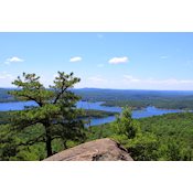
Norvin Green State Forest has one of the largest concentrations of trails in NJ. Nearly all are “difficult.” There are 27 scenic views, with names like “Wyanokie High Point” and “Yoo-Hoo Point.” Take rugged shoes.
With more than 5,000 acres, Norvin Green State Forest has one of the largest concentrations of trails in the state. Norvin Hewitt Green, nephew of Ringwood Manor owner Abram S. Hewitt, donated much of this land to the State of New Jersey in 1946. There are two geographically distinct sections.
-
South of West Brook Road: The section of the state forest south of West Brook Road is often accessed from the Weis Ecology Center. Although the buildings are closed to the public, the parking area remains open to hikers. The trails in this area can also be accessed from the Otter Hole parking area on Glenwild Road at the West Milford/Bloomingdale border.
-
North of West Brook Road: This geographically separate part of the Norvin Green Forest extends north of West Brook Road into the Monksville/Stonetown area. The North Jersey District Water Supply Commission also has watershed lands in this area to the west. Although the trail network in this area is not as extensive as in the area south of West Brook Road, several trails traverse the area, offering rugged climbs and expansive views.
South of West Brook Road
-
This section has the largest concentration of trails in the park, fifteen in all (if the co-aligned Highlands Trail is included). As a result, portions of many trails may be combined for loop hikes. There are at least sixteen "scenic views" identified on NY-NJ Trail Conference's North Jersey Trail Map #115, with names like "Wyanokie High Point," "Yoo-Hoo Point," and "Carris Hill."
-
Trails range in length from 0.4 to 6.4 miles. The NJ Park & Forestry Service identifies ten trails, of which one is "easy," three "medium" and the rest "difficult." The "easy" Macopin trail [1.0 mile; white] requires walking in 1.5 miles on the "medium" Otter Hole Trail [green] to reach it. NY-NJ Trail Conference maps are located at kiosks and three trailheads. Total miles of trails: 29.5.
North of West Brook Road
-
The northern section of the Hewitt-Butler Trail extends from the intersection of Greenwood Lake Turnpike & East Shore Drive in Hewitt southward to West Brook Road near the Ringwood/West Milford boundary [7.2 miles; blue]. Together with portions the Hewitt-Butler and Horse Pond Mountain [white] trails, the Burnt Meadow Trail [yellow] can be used to make a 5.8-mile "lollipop"-loop hike.
-
Two new trails opened in summer of 2008. The two-mile Lake Sonoma Trail [orange] and the 1.6-mile Overlook Rock Trail [white] allow even more loop hikes and gorgeous views of the area. The Lake Sonoma Trail connects the Stonetown Circular Trail to the Overlook Rock Trail. The Overlook Rock Trail connects the Lake Sonoma Trail to two points along the Hewitt-Butler Trail.
-
The Stonetown Circular Trail's 9.4-mile loop is so strenuous that many hikers choose to cover only half of the trail at a time [red triangle on white] At least half the trail is within the North Jersey District Water Supply Commission watershed [see advisory below].
-
There are four trails, ranging from 1.2 to 9.4 miles. Total miles of trails: 23.5
-
Advertisements
